Overview
Length: 9.3km
Elevation: 250m
Type: Loop
Time: 1hr 30mins
Introduction
When friends and family visit us, we almost always take them to the Castell de Guadalest. It’s become a tradition.
The drive from Denia through the mountain pass via Tàrbena is a treat in itself, with winding roads that open up to jaw-dropping views of rugged peaks and deep valleys. Without fail, there are gasps from the backseat, followed by, “I never knew Spain had so many mountains!”
But this time, instead of just exploring the castle and strolling through the picturesque village, we decided to switch things up. We wandered down to the reservoir and noticed kayaks for rent – just €9 each.
It seemed like too good an opportunity to pass up. Even in January, the water shimmered in shades of blue and green, reflecting the surrounding mountains. Thanks to the heavy rains over the last few months, the reservoir was full, making the experience even more magical.
While we paddled, Markus’s sharp eyes spotted a group of trail runners weaving through the landscape. Naturally, he stopped to chat (as he does) and asked about the route.
They pointed us toward an AllTrails loop nearby, which sounded too good to resist.
We resolved to tackle it that weekend – and we did!
About the Embalse de Guadalest
The Guadalest Reservoir, tucked away in the Marina Baixa region of Alicante, is a lifeline for the area. It provides piped water to towns and cities, including bustling Benidorm.
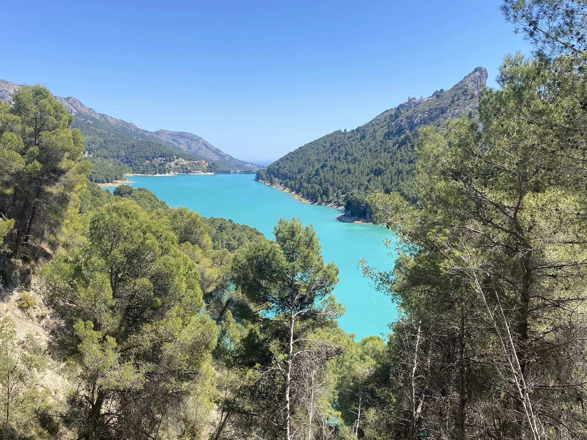
But it’s also simply stunning to look at, with a rich turquoise colour that takes your breath away!
Being the curious type, I couldn’t help but dig into its history. That’s when I discovered two fascinating facts that made me appreciate it even more.
First, the reservoir was never officially inaugurated. For something so vital, it’s strange to think there wasn’t a ribbon-cutting ceremony or a moment of grand celebration. It simply began serving its purpose quietly, without fanfare.
Second—and this one really impressed me—the reservoir took 13 years to build, relying heavily on manual labor and horse power.
Imagine that!
A massive project like this, stretching across decades, and not a single work-related accident was reported. It’s almost unheard of apparently. When Markus is installing a Nordic sauna with a team of 3 using specialist tools there’s almost always some mishap—a stubbed toe, a bloody finger, a sprained back.
I did enjoy poking fun at Markus with this fact!
The reservoir hasn’t had an easy journey, though. Like much of Spain, it faced dire lows during the 2024 drought, with water levels plummeting to historic depths. We’d read reports of the cracked and dry bed, a sad sight for such an essential resource.
But when we visited in January 2025, it was almost unrecognizable from those images. Thanks to the heavy autumn rains, the reservoir had filled up again, its vibrant blue waters lapping at the shore.
The Trail Running Route
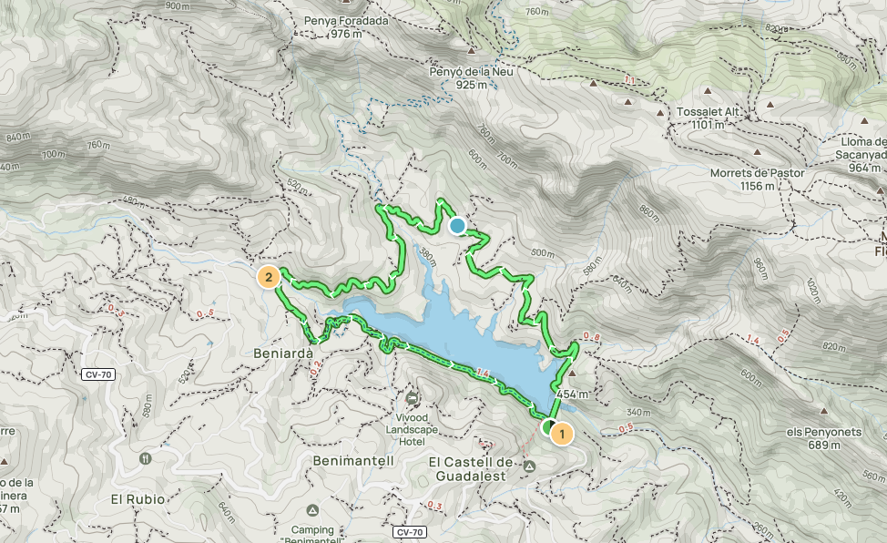
The route starts just before you reach the dam itself, at the bottom of the hill where the famous castle of Guadalest sits.
From here, you simply loop around the reservoir.
If you check AllTrails, most people recommend taking the route anti-clockwise. After doing it ourselves, I can absolutely agree. Here’s why: the northern side of the lake is more challenging, with narrow asphalt roads and stretches where you can’t even see the lake.
There’s also a bit of an uphill grind right at the start—not steep, but enough to make your glutes work.
Meanwhile, the southern side is a completely different experience—gravel paths, right at the water’s edge, with incredible views. It’s definitely a case of saving the best for last.
Anyway…
We started by crossing the dam before heading up into the hills. The route then follows narrow asphalt roads that twist through the countryside. Navigation here can be a little tricky, and we did end up slightly off track.
At one point, we stumbled upon an abandoned swimming pool and an old quarry—a detour we didn’t mind at all. Markus, as always, couldn’t resist a quick research into the history, discovering that the quarry used to produce “áridos” stone very similar to what we use for non-slip flooring around the saunas and plunge pools he installs.
Alicante, it turns out, is a global exporter of stone aggregates which are mixed with resin binders in resin-bound flooring.
TIP: Good signal is a must!
If you’re like us and don’t mind a little unexpected exploring, the occasional detour is part of the adventure. But if you’d prefer to stay on track, I’d recommend ensuring you have a strong phone signal or downloading the route in advance.
As you round the northern side of the lake, the views finally start to open up. We passed through the village of Beniarda, where you’ll find a couple of bars if you fancy a quick drink or snack. On a quiet Sunday afternoon, we only encountered one car while running along the roads—but I imagine that in summer, it’s a different story.
For the best experience, aim for early mornings or off-peak times.
Now for the good part.
The southern side of the reservoir is where this route really shines. The path winds low and close to the water, offering breathtaking views across the lake. It’s peaceful, scenic, and perfect for picking up the pace on the gravel roads.
While the route is roughly 75% asphalt (which was a little disappointing as trail runners) it did make for a smoother run without needing to constantly watch our footing.
It’s one of the less demanding routes in Alicante, but the views on the southern side make it absolutely worth it!

AllTrails route. “Guadalest Reservoir”.

The far-side (northern side) of the lake is a little boring dare I say, with narrow asphalted roads.

As soon as you get past halfway, the views open up and it’s all worth it! The rest of the route (if you’re going anti-clockwise) skirts the southern part of the lake. You can see that on the right-hand side in this picture.
